Overview
Strangford Lough is an easy trip, great for a first time organiser or just for the lazier organiser. It’s nearby, from Dublin, three hours will have you in Strangford, drink is cheap, the people are nice and the diving’s not half bad either. The club runs a training course, often the Advanced Diving Techniques Course, from Portaferry each year. There are a range of dives with plenty for ocean divers but also several dive-leader plus dives.
If you are doing an ocean diver trip without boats suggest doing the Alastor and the Inner Lees in reverse geographic order. Inner Lees is much more welcoming and a good place to let new Ocean Divers, or nervous divers of any grade to find their feet. Alastor is a lovely dive but its deep, dark and cold and can be intimidating.
Contacts
Ronan Barry put together this guide though many people have done trips to Strangford over the years. Other people to pester include Mark Lee, Andrew Thomson, Sarah Doyle or Sarah Bothwell. That said, everything you need should be in this guide more or less. Lisburn dive here regularly.
Boats
If you are going to park the boats in the area outside Barholm, on front of the Queens Marine Research building, do contact Queens first and make sure it is ok . They don’t mind, once you ask! Also, wheel clamps and a couple of locks to lock the compressors into the trailers would be useful.
You can launch at Portaferry. It has to be timed between ferry landings but otherwise an easy launch. It’s fine at all stages of the tide. You can moor the boats in the marina once you run it by the harbourmaster. You can find him in a grey house around three doors to the left of the Slip Inn. On the right hand side of his house is a yellow building called Hazel’s House. If you ask for him in the Slip Inn you won’t go far wrong anyway. The berths cost:
- 0 – 6hrs: 50 pence per metre, 5 pounds minimum (2005).
- 6 – 24hrs: 1 pound per metre, 10 pounds minimum (2005).
Bring as much petrol with you as you can. Petrol is much more expensive in the north.
Sites
M.Y. Alastor, Ringhaddy Sound
The Alastor is probably the most popular dive in the lough, mainly due to its accessibility (it can be dived from either the shore or a boat) and its sheltered location.

The luxury diesel yacht Vita was built for renowned aviator Sir Thomas Octave Murdoch Sopwith by Camper & Nicholsons in 1926. After changing owner in 1929 (Sir John Shelley-Rolls descendent of Percy Bysshe Shelley) and being renamed Alastor, she was eventually acquired by the Ministry of War Transport at the outbreak of WWII, and served as an armed transport and anti-submarine vessel throughout the war. Whilst at Ringhaddy for repainting, she sank under suspicious circumstances in 1946. The insurance report cites an accidental fire on board for the loss although many believe that it was deliberately set.
M.Y. Alastor, Ringhaddy Sound – Wreck Guide
| This 1930s motor yacht hit the news last year when her true identity was revealed. John Liddiard travels to Northern Ireland to dive this rich man’s toy. Illustration by Max Ellis | |||
|
|||
- Images
- Irish Wrecks Online
- Thomas Sopwith
- A good overview picture of the Wreck – http://www.divernet.com/Wrecks/wreck_tours/159399/wreck_tour_80_the_alastor.html
The wreck, which is 43m in length, sits upright and intact in 22m of water but comes up to 18m (HW) at its highest point. Visibility can be poor at times. This is a relatively sheltered dive which can be attempted on any state of the tide although slack is best and occurs approximately 1hr and a half – 2hrs after Belfast HW/LW. It is generally not very tidal (except mid-run on a spring tide) so is diveable at any stage.
The wreck is substantially intact and allows for a relatively easy circumnavigation. Little remains of the deck plates, promenade deck or upper structures. The funnel at eighteen metres is the highest point of the wreck; look for the large resident wrasse and conger in the stack. There are covered gangways going down both sides that allow easy access to the portholes looking into the remaining accommodation sections, including a bath visible on the starboard side just forward of the funnel. Underneath the bathtub and hawser bollards and winches in the fore section of the deck is a good place to look for conger eels, although the large resident eel who lived on the starboard side in the anchor winch was missing on our last visit and seems to have been fished. The wreck attracts large numbers of large velvet swimming crabs and edible crabs while the side plates are coated in dead-mans fingers. Dog-welks, shore crabs and hermit crabs litter the seabed beside the wreck and there are some large dahlia anenomes to be found.
Bring a good light, dive in small groups or by pair where possible and try to avoid stirring up the silt.
Diving the Alastor from a boat
Ringhaddy is about a 20-30min boat ride from Portaferry/Strangford although obviously this will depend on the sea state. See below for details on shore diving. As of December 2006 the wreck does not have a permanent shot on it. Irish Wrecks online give GPS coordinates for it and make sure you have a working sounder.
The following transits are courtesy of Ronan Barry. They were slightly hard to come by so a little imagination is needed with them.
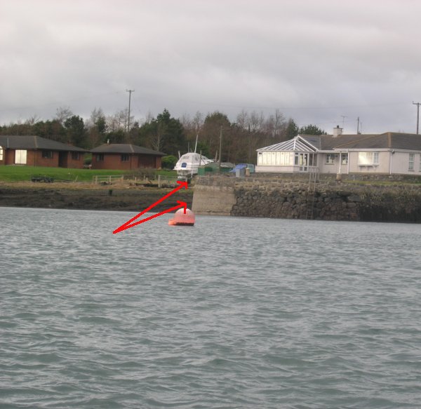
Alastor, transit 1
Looking in a westerly-ish direction (I forgot to take a bearing so you’ll have to run with me on this one) you’ll see a house, as shown below. There is a gateway just to the left of the quay wall and if you roughly line up the right-hand gatepost and the edge of the quay wall you’ll be close enough.
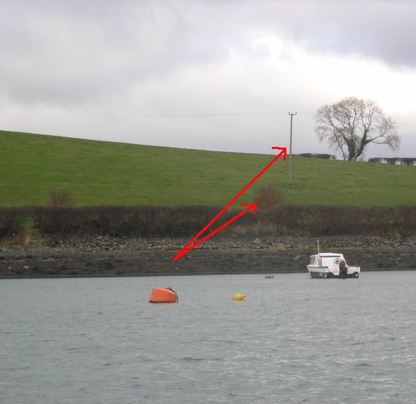
Alastor, transit 2
Next, turn approximately 90° to your right and you should see the scene above. If you line up the brown bush with the telegraph pole in the middle of the field you won’t be too far off. If you’re a little slow, remember that this photo was taken in January, the bush will be green for most of the year!
Diving the Alastor from the shore
Although many in DUSAC are all but allergic to shore-diving – if in doubt send an email around trying to organise a Sandycove dive and wait for the deafening silence – the Alastor is a great shore dive only two hours north of Dublin.
At Ringhaddy pier, which is privately owned and guarded ferociously, park your cars on the left. Your access point is at the shingle beach to the left of the jetty. Looking out to the Alastor the wreck is not shotted (as of December 2006) but lies about twenty yards south/southwest of the old RNLI lifeboat. With the lack of a shot and possible tide (see above) it is easiest to make the fin out along the bottom. This takes about 6 or 7 minutes typically.
Drop down into about two or three metres of water about three metres away from the northern corner of the jetty and fin towards the edge of the jetty. You are after a steel pipe containing thick dark cable with which may be covered in silt but should be fairly conspicuous a few yards out from the jetty wall. Once you have found the pipe/cable, follow it away from the pier. Be careful, disturbing it will stir up a lot of silt not to mention annoying other divers trying to follow the line below. Very quickly at approx 6m depth you will come across a (currently thick black) rope tied off to the cable and branching off left. There are a number of dead lightsticks tied at the junction. Follow this rope not the cable to the left, again being careful not to kick up or disturb the silty bottom. It is best to swim side by side above the line. In bad viz conditions you have no choice but to ring the line (not pull) with your finger and follow it one behind the other. Follow it deeper and darker to a maximum depth of approximately twenty five metres (on a high tide). The line is tied down in some places, and as well as this, changes to cable nearer the wreck. You will know you are going the right way as you pass two tractor tyres along the route. Again it gets very silty as the line can be buried, particularly on the muddy sections shallower than 12 metres. It is tied to the stern of the ship, she is oriented pointed north. Keeping a reasonable pace – she lies approx eighty metres offshore – you should hit the wreck just over ten minutes into the dive.
If gas and time allow it is suggested that divers circumnavigate along the gunwale hitting the line again with plenty of gas for the return swim to shore. If constraints allow, the swim back rewards a very leisurely pace. The seabed around the line is covered in crabs (including the long-clawed porcelain crab- they are the small encrusted ones with both claws stretched out nearly horizontally), enormous starfish, three different types of prawn and fine examples of sand and rock gobies.
Empire Tana / Lees Wreck, Ballyhenry Bay
The Lees wreck started out life in 1923 as the “Carso” built in Trieste, Italy. It was captured during World War II by the Allied forces in 1943 and was renamed HMS Empire Tana. She was used in the D-Day landings as part of the Gooseberry Breakwater on “Sword” beach (British). After the war (1947/1948) she was purchased by the breakers yard ‘John Lee’ operating from Ballyhenry Bay. Whilst delivering the ship to the breakers, she struck a rock and sank and subsequently broke in two. The wreck became known locally as Lees Wreck but that hardly gives due credit to her role during the D-Day landings.

Inner Lees
The Inner Lees is the bow section of a large ship which is sitting upright in 12m of water only 5mins from Portaferry. As with the Alastor the Inner Lees can be dived from either the shore (100m fin) or a boat and at any state of the tide. This is an easy dive where the visibility is normally 2-4m. This wreck breaks the surface (except at high water) and so can be found easily without transits. It is an excellent dive for novices and experienced diver s alike. There is a lot of life to be found underneath the wreck particularly on the channel side. There are plenty of opportunities to enter the wreck and practice penetration skills, line laying etc. It would also make a superb night dive.
Outer Lees
This is the stern section to the Inner Lee’s bow and is located further out into the lough meaning that it is only accessible from a boat, a journey which will take approximately 5-10mins from Portaferry. The wreck lies in 15m of water and will normally break the surface although it may be covered during HW springs. There can be quite a current on this wreck at certain times, so it is only diveable on slacks. The best slack period on this wreck starts approximately an hour and a half after Belfast LW or an hour and forty five minutes after Belfast HW and lasts for full ebb if on neap tides or for around 3hrs if on spring tides. Both the Inner and Outer Lees may be penetrated quite easily and so are ideal for training purposes.
The Pins
This is thought to be the wreck of the Swedish barque S.V. Zarina wrecked in the year 1700 approx.
This dive is another that is accessible from both the shore and a boat and lies in Ballyhenry Bay at about 12m. The wreck itself is wooden and has been flattened and overgrown with kelp over the years but there is still lots of life present. This wreck, like the Outer Lees, is tidal and is best dived approximately 2hrs after Belfast HW with slack lasting for 3hrs on a spring tide and for the full ebb on neaps. However, when the tide has turned after LW there can be quite a current which can make it difficult to make it back to the shore. The wreck is only 5mins from Portaferry.
Ballyhenry Drop-Off
This is a wall dive that slopes from 10m down to 25m and then drops suddenly to more than sixty metres. There is plenty of life on the wall and the visibility can be quite good due mainly to the strong tidal currents that the site is exposed to. As a result the drop-off can only be dived on a slack as there are strong down currents at any other time here. As slack is very short on this site either a dedicated cox or very short dives are necessary. Slack begins approximately 1hr 30mins after Belfast HW/LW and lasts approx 20mins at HW or 5-10mins at LW (less on spring tides). During these windows divers may drift gently in one direction, stop, and then drift gently in the opposite direction as the tide turns. Best option is to get out there early and wait. The site is a 10min boat run from Portaferry.
The above would be the best of the diving inside the lough but if the weather were good you may want to try some of the dives situated outside, these are rarely dived by the club so may be worth a look.
Gun’s Island
This is a scenic dive which can be dived at any state of the tide. The dive itself has a maximum depth of 16m and takes you around a small rocky outcrop which is close to the mainland. There are sheer walls on both sides, large boulders and the odd swim-through. As the sea-bed is made up of small stones the visibility can be quite good here as there’s not much silt to be kicked up. This dive is around 20-30mins from Portaferry depending on the sea state.
S.S. Georgetown Victory
The S.S. Georgetown Victory was built as a Victory Class troopship in 1945 in the U.S.A. In 1946 she left Sydney for Glasgow with 1,200 Royal Navy men and Marines due for demob after WWII. Inexplicably she mistook Strangford Lough for the Clyde and ran aground. Winter storms later separated the wreck into two parts. Some sections of the wreck were subsequently salvaged.

This wreck lies in about 10m of water on the way to Guns Island. It is pretty big with wreckage scattered about although there are large parts of the wreck which are still intact. There is normally a decent amount of life on the wreck but because it is so shallow kelp can be a problem. It is best dived around Belfast HW/LW but the current isn’t too bad on it. If the visibility is good this can be a good dive, if not I’d pass on it. The wreck is 20-30mins from Portaferry.
S.S. Bangor
Built in 1894 she sunk in 1934 while carrying granite blocks, from Portland, to be used in the construction of Stormont, when she struck Butter Pladdy. After being part salvaged, she floated off the rocks and eventually sank at her present location.

The Bangor is a wreck lying in 32m and so is only suitable for experienced SDs and upwards. Although the tide never gets too bad on it and despite the fact that it is in theory possible to dive at anytime it is best on slack, avoid mid-run at the very least. Slack is around Belfast HW/LW. Again, the wreck is 20-30mins from Portaferry.
S.S. Hunsdon
The ship was built originally as the “Arnfried” for the Hamburg-Afrika Line by the Weser Co., Bremen, and launched in April 1911. It was captured by the British in west Africa in 1914 and renamed “Hunsdon”. The ship transported hay and oats between the west coast of England and France until she was torpedoed by UB-92 (type UBIII) in October 1918 bound Belfast from Le Harve. Her last port of call was Dun Laoghaire, Co. Dublin.

As this wreck is lying in 38-40m it is a dive suitable only for experienced DL+. As well as this the visibility can get very bad and divers can find themselves disorientated and inadvertently end up inside the wreck. The stern is covered in nets and care should be taken to avoid entanglement. On the plus side, the wreck has lots of life and the dive can be great when there is decent visibility. Slack occurs roughly at Belfast HW/LW with relatively long windows, 2hrs on springs and 3hrs during neaps. The 2-3hr window during mid-run should be avoided.
The Routen Wheel
This is supposed to be a great, if slightly scary dive with depths ranging from 15-30m. The name comes from the swirling, whirlpool effect that the tide creates in this spot.
Jimmy’s Wall
There is a short wall which drops sharply from 20 to 40m causing the tide to rip past at high speed. I don’t know and couldn’t find out anything more about this dive but it comes highly recommended. Probably only suitable for DL+.
Other sites
Safety
You need the usual boat safety equipment: O2, 1st Aid Kit, flares, VHF, GPS. Also make note of the following:
- Belfast Coastguard
- VHF Channels 04, 16, 67 and DSC 70
- Lifeguard Station
- Portaferry, Atlantic 75 Inshore Lifeboat
- Emergency services
- 112 (or 999) on land
- Recompression chamber
- Craigavon
- Weather
- Weather Dial 1550 123 855 (or 853 for Ulster)
- RTE Radio1 (88-89fm) at 0602, 1253, 1655, 2355
- VHF 0103, 0403, 0703, 1003, 1303, 1603, 1903, 2203
- Warnings on VHF (channel 16) 0033, 0633, 1233, 1833
Local Facilities
There are two dive centres close by.
Dominic Mallon,
Strangford Dive Centre,
The Square,
Strangford,
Co Down,
BT30 7ND.
Tel: 028 44 881 981
Fax: 028 44 881 981
Mobile: 07789 82 77 92
Dave Vincent,
DV Diving,
138 Mountstewart Road,
Newtownards
BT22 2ES.
Telephone & Fax +44 (0)28 91 464671.
Barholm also has a compressor where you can get air fills. However it hasn’t been working for a while so maybe give them a ring before you go up if you’re planning on using it.
Accommodation
Usually the club chooses to stay in the Barholm Hostel in Portaferry (Tel: 028 42729598), which has a self-catering kitchen and its own compressor. This place holds up to 38 people so will be able to cater for almost any diving trip that you care to organise.
If for some reason the hostel is unavailable the Fiddler’s Green B&B (Tel: 028 42728393) is a more than adequate substitute. The house sleeps 12/13 guests and is part of the Fiddler’s Green Pub which means that you’ll never have far to go for a pint. Parking in the square is tight enough and as a result it will probably be necessary to lock any trailers that you’ve brought along down by the marina. Also, wheel clamps and a couple of locks to lock the compressors into the trailers would be useful.
There is also a house you can rent for accomodation. It’s about 2-3miles outside strangford. I think it sleeps up to 8. Contact Diarmaid +447753207704. I thinks it’s cheap and cheerful and he doesn’t mind divers.
Amenities
There’s a small supermarket in Portaferry to buy lunch etc. There’s also a chipper and chinese for take-away. Barholm is self-catering if you want to cook yourself but they also do breakfast. There is plenty of room for everyone to sit around and eat. There is an ATM in Portaferry that as far as I know charges a small fee. Petrol station? Petrol expensive!
Entertainment
As far as pubs go, there are plenty in Portaferry but we’d normally go to the Fiddler’s Green or the Slip Inn. The Fiddler’s is a lively bar with traditional music every Friday, Saturday and Sunday night. Great for a laugh but can get a little cramped if you’ve got a large crew with you. If you’re after a more sedate bar the Slip Inn is what you want, popular with locals and shows all major sporting events if you’re that way inclined.
For no-diving days there’s also the Exploris aquarium in Portaferry itself or ice-skating in Belfast.
Info
There is more information on the area and diving in the following:
- Underwater Ireland Book
- Chart 2156 Strangford Lough/2159 Strangford Narrows
- Chart 5011
Getting there (Portaferry)
- Take the M1 Northbound. This eventually brings you to Newry by which time its designation has changed to the A1. Expect it to take roughly 1 hr and 15 mins to reach the far side of Newry from clubrooms (without delays).
- In Newry follow the signs for the A1 to Belfast until you come to the junction with the A25 (signposted Rathfriland, Hilltown).
- Follow the signs for Hilltown and then on to Castlewellan where you follow signs for Belfast, Downpatrick.
- Pass through Clough, and when you come to a roundabout take the 2nd exit (signposted Downpatrick).
- In Downpatrick follow signs for Comber and then Strangford.
- In Strangford the ferry terminal will become obvious, normally there will be cars queuing to board the ferry. The fare at the time of writing was 4.80 for each car and driver, 9.30 for a car and box trailer and around 13 for a car and boat trailer. Each additional passenger is 1. Ferries leave each side approximately every 30mins and although there is a timetable the service rarely runs to it, if anything it’s more frequent than the schedules suggest.
Getting there (Ringhaddy)
- Follow the same directions as above until you get to Downpatrick.
- Once in Downpatrick follow signs for Comber and then go through Killlyeagh. Approximately 5km after the village you’ll see a brown sign (on the right) to go right that says “Ringadufferin Golf Club 1/2 KM”. Take this turn. (Its easy to miss this sign. It comes up on you pretty fast. If you miss it there is an easy place to turn just up ahead on the left)
- Once the turn has been taken follow the road around until eventually you pass the golf club itself. If you are towing a boat for some reason this is a good place to leave it; they were happy enough for us to park it there when we asked. The roads from here onwards are too narrow for a boat.
- Keep following the road around to the left and stay on the road through a series of dips. Ignore any small side-turns. A few minutes after the golf club you’ll see a white house on the right as you go up a hill with a prominent sign saying “Mayday Marine”.
- Immediately after the house the main road you have been following goes off in a fork to the left. Do not follow the road left but take the marginally smaller fork to the right. This road is called the “Ringhaddy Road”.
- This road will take you all the way down to the site, passing very picturesque inlets first on the right and then the left as you wend your way to the jetty. The journey from Newry to Ringhaddy Pier takes around 1 hr 15 mins, (giving total journey time to Dublin 2 hrs, 30 mins minimum).
- If based in Barholm take the ferry back to Portaferry and take the A25 to Downpatrick.
- In Downpatrick pick up the A22 northbound and go through Killyleagh. Approximately 6km after the village you’ll see a sign to go right that says “Ringadufferin Golf Club 1/2 KM”. Take this turn and follow the description as above.
- If based in Belfast/Bangor take the A22, pass through Killinchy. A few kilometers south of the town you’ll happen on the same sign inviting you to turn left for the golf club.


