Dublin Bay offers lovely local diving to the club, highlights including sunken wrecks and fun drift diving! Being Dublin based, we do much of our diving here. Between April and October, we moor the club RIBs in Dun Laoghaire harbour. With the boats in the water, we can arrange dives at short notice, and without having to launch and recover each time. In high summer, we take advantage of the long daylight and dive on weekday evenings as well as at weekends. Check out this video on what a Dublin dive typically looks like!
Boats
It is possible to launch at the following sites.
- South County Dublin
- Dun Laoghaire, Coal Harbour (our usual)
- North County Dublin
- Howth
- Rush (not accessible 1.5 hours before and after low water due to sand bars)
- Skerries (dries out 2 hours either side of low water on springs)
Charts
The following charts and maps cover the area.
- chart 1415 Dublin Bay
- chart 1447 Dublin and Dun Laoghaire
- chart 1468 Arklow to the Skerries Islands
- Discovery Series Map 50
Dive sites
Outlined below is a selection of the dive sites in and around Dublin Bay, most of which the club has dived.
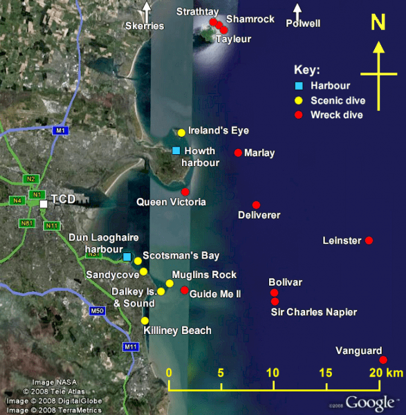
Dive sites in and around Dublin Bay
Scenic dives – Dublin Bay & South
Sandycove
| Grade | Trainee |
|---|---|
| Depth | Up to 6 metres |
| When | High Water |
This is a small beach where Novices have often had their first taste of the open water. Visibility is usually poor, particularly near the shore, and there isn’t much marine life, barring the odd starfish. However, Sandycove has a sheltered beach with a safe 6m depth for training and assessed dives. We mostly dive from the shore, but sometimes use boats when looking for deeper water.
This site is bordered on one side by the forty-foot swimming area. It is very important that divers stay clear of here for two reasons.
- Local by-laws prohibit scuba diving in the swimming area
- injury can arise if a swimmer jumps in on top of a diver who is oblivious under the water
The Outfall (The Lady’s Stairs)
| Grade | Trainee |
|---|---|
| Depth | 10 – 12m |
| When | Approx 1.5 hrs before HW, 1 hr before LW |
Just around the corner from Sandycove, the Outfall is reached by a concrete walkway running out to sea. Finning out from here, you can find depths of 10 to 12 metres can be found. The site is quite exposed to currents, so should be dived on slack water only. Instead of the sandy bottom found in Sandycove, the outfall features broken rocks and crevices where crabs and lobsters hide. Some divers have even seen congers lurking amongst the rocks. If you are on spring tides, do not dive this site at low water as entry and access is too difficult.
Close to shore this site features the afore mentioned rocks and boulders. They are mostly overgrown with kelp and sea weed. If one ventures further out (easterly direction) the ground changes to sandy/silty and the rocks and boulders are pretty clean of sea weed. Instead you’ll find the ever popular deadman’s fingers and amemonies. On the sandy areas pipefish and flat fish can be found. Do remember to turn westwards before surfacing though, otherwise you’ll face a rather lengthy fin back to shore.
Scotsman’s Bay
| Grade | Trainee |
|---|---|
| Depth | 6 – 20m |
| When | Approx 1.5 hrs before HW, 1.25 hrs before LW |
This bay just south of Dun Laoghaire harbour is where we carry out most of our assessment dives for the dive leaders and advanced divers. You can find depths from 6m to 20m at various stages of the tide. For the most part, the seabed is fine sand/silt. Flat fish are fairly common as are common Dublin Bay shrimp and sea pens.
Muglins
| Grade | Ocean Diver |
|---|---|
| Depth | 10 – 25 metres |
| When | Approx 1.5 hrs before HW, 1.25 hrs before LW [See here] |
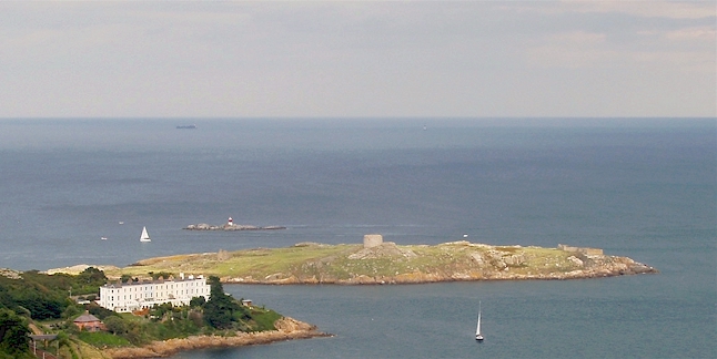
Dalkey Island with the Muglins Rock behind. Photo: Padraig O’Flynn
This is our most dived site in Dublin Bay. It is an oval rock (about 250m long) just north-east of Dalkey Island. As with most Dublin Bay sites, this site is subject to strong currents and best dived at slack water. If the current is strong try and stay close to the rocks and stay shallow. However, just outside slack, it can make for a nice drift dive if the current is not too strong.
The rock drops to about 25m and is full of nooks and crannies containing sponges, anemones, crabs and lobsters (by the dozen), conger eels, gunnels, dogfish, every kind of wrasse, bib, pollack, ling and plenty of seals. At the south end, deeper down, you can find anchors and other remains of shipwrecks. This fabulous dive is often over looked but offers some of the best dving on the east coast – look out for young seals coming to play with divers in late July/August in particular
A rescue sausage is a must for all divers here, as well as at least one delayed surface marker buoy per buddy pair.
Dalkey Island
| Grade | Ocean Diver |
|---|---|
| Depth | 5 – 30 metres |
| When | Approx 1.5 hrs before HW, 1.25 hrs before LW [See here] |
The south end of the island (on left in above photo) is very similar to the Muglins, and often diveable when it is too rough to dive the Muglins. Boulders hiding crabs, lobsters and ling gradually give way to a sandy bottom close to thirty metres where you can find snoozing dogfish. It is a good spot for new sports divers to increase their depth range gradually.
Dalkey Sound
| Grade | Ocean Diver |
|---|---|
| Depth | 20 metres |
| When | Off slack/mid-tidal range |

Dalkey Sound, seen from Dalkey Island. Photo: DUSAC
Dalkey Sound is the best choice when it is not possible to dive on or near slack. The tide can fly down between Dalkey Island and the mainland giving a really exciting drift dive. The bottom ranges in depth from around 10 to 20 metres and is mostly sand, with the odd rocky outcrop. You’ll see lots of crabs and dogfish, and in the summer the bottom is often covered in a seething mass of brittlestars.
Killiney Beach
| Grade | Ocean Diver |
|---|---|
| Depth | Up to 6 metres or so |
As an alternative to Sandycove, we sometimes do assessment shore dives from Killiney Beach. It’s only really possible if there’s no swell, as the beach is very exposed to waves rolling in.
Wreck diving from Dun Laoghaire
Dublin Bay has long been a busy seaway, and hundreds of ships have been wrecked over the centuries. Some of the more recent ones are still fairly intact, shallow enough for air diving, and outside the shipping lanes. Some we dive often; others we’ve not visited in many a year.
Bolivar
| Grade | Ocean Diver |
|---|---|
| Depth | 10 metres |
| When | Best dived 1.5hr before high water, 1hr before low water |

M.V. Bolivar wrecked on the Kish Bank, 1947
The Bolivar was a Norwegian cargo and passenger motor vessel built in 1940. En route from Uruguay to Oslo via Dublin, she was caught in a snowstorm and hit the Kish sandbank. The ship was evacuated and later broke in two. The wreck was subsequently dispersed with explosives, though parts are still reasonably intact.
The Bolivar sits on a sandy seabed in about 12m. The area around the engines still stands quite high, but the rest of the wreck consists of scattered beams, masts and plates half sunk in the sand. The wreck is home to many fish species: shoals of large pollack often hover nearby, and there are lots of holes for congers to hide in.
Due to its scattered nature and lack of distinguishing features it can be very difficult to orient yourself. Either use a distance line to return to the shot or else be sure to have, and be able to deploy, a delayed SMB. Because the wreck is on such a shallow bank it is very susceptible to swells and the currents can be quite strong around it.
At night, conger eels come out all around the wreck. Jump in if that’s your cup of tea!
Glenorchy
| Grade | Ocean Diver |
|---|---|
| Depth | 10 metres |
| When | Best dived 1.5hr before high water, 1hr before low water |
The Glenorchy was an iron sailing ship of 1300 tons, lost in 1869 while carrying a cargo of iron, coal and spirits (the cargo was salvaged). Due to a navigational error (the captain applied the compass deviation in the wrong direction when tacking) she struck the Kish Bank on New Year’s Day.
Although reasonably broken up there is a very distinct funnel, a good section of her hull intact, and a line of bollards very recognisable. The life seen there included several congers, a lobster, tompot blennies (including a pair of large ones fighting), a number of butterfish, and some very large pollack, as well as schools of smaller fish. The sands seem to have shifted to reveal a great deal more wreckage this year (2010) than in 2008 when the club dived it previously.
The wreck is not so broken up that a distance line should be required to return to the shot. However each buddy pair should have and be able to deploy, a delayed SMB. Because the wreck is on such a shallow bank it is very susceptible to swells and the currents can be quite strong around it.
Sir Charles Napier
| Grade | Ocean Diver |
|---|---|
| Depth | ~ 10 metres |
| When | Best dived 1.5hr before high water, 1hr before low water |
The Sir Charles Napier was a full-rigged sailing ship, wrecked on the Kish Bank in 1855. Apparently some large pieces of machinery are visible, though little else remains to be seen.
RMS Leinster
| Grade | Sports Diver |
|---|---|
| Depth | 33 metres |
| When | Same as Bolivar |
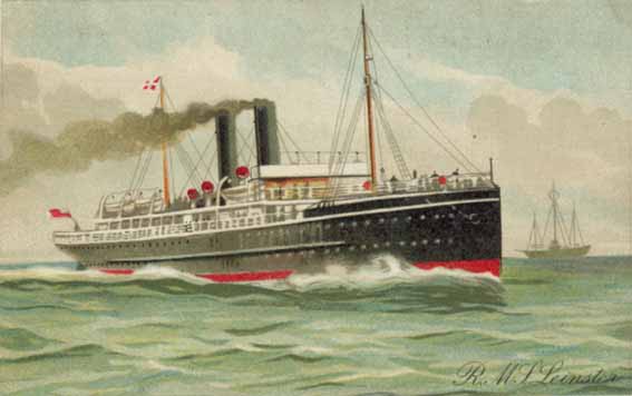
RMS Leinster
The Leinster was one of a quartet of fast steamships named after Ireland’s four provinces. Built in 1897 by Cammel Laird of Birkenhead for the City of Dublin Steam Packet Company, she was used to carry mail and passengers between Britain and Ireland. She grossed 2,646 tons and measured 115m x 23m x 13m. Her twin screws were powered by an 8 cylinder triple expansion steam engine, and she could reach 24 knots.
On her final voyage, The Leinster was bound for Holyhead from Dun Laoghaire just three weeks before the end of the First World War. On board were hundreds of passengers and crew, including many soldiers. Some way short of the Kish Bank, she was hit by two torpedoes fired by U-boat UB-123. The first struck in the mail room, killing most of the postal workers. The second torpedo hit in the engine room amidships, and the Leinster then sank rapidly. Most passengers escaped from the wreck, though many drowned whilst waiting to be rescued. In all, an estimated 527 lives were lost.
The Leinster lies about 22 km west of Dun Laoghaire (40 minutes to over an hour, depending on the weather) with her bow pointing south. The bow stands proud of the seabed, a little apart from the rest of the wreck, which is largely collapsed and settling into the sands. When the visibility is good, there is plenty of marine life to see – shoals of fish, congers, etc. This is a very substantial wreck and, if uncovered by the sand, is a superb dive.
The wreck is subject to strong tidal currents outside of slack water, so best dived on a neap tide. In poor visibility (especially on springs) it can be hard to navigate, so a distance line is useful. A further consideration is that it lies in the path of the HSS ferry. The site is permanently shotted but these shots are submerged at HW slack. Prudent to always bring a shot out to the site in case bouys are submerged or have been swept off.
Permission to dive the wreck should be obtained from the owner, Desmond Brannigan, who can be contacted via the Irish Underwater Council.
More info:
SS Guide Me II
| Grade | Experienced Sports Diver |
|---|---|
| Depth | 33 – 38 metres |
| When | 1.5 hrs before HW, 1 hour before LW |
The Guide Me II is our most-dived wreck. It’s near to Dun Laoghaire (20-30 min), deep enough for a challenge yet diveable on Nitrox, handy-sized, and full of marine life.
The Guide Me II was a steel-hulled drift net fishing boat built in Aberdeen in 1907. In 1915, she was hired by the British Admiralty, fitted with a six-pound gun, and put to use as an anti-submarine coastal patrol boat. She sank in 1918 after a collision off the Muglins, and now lies about 1.4 km east-south-east. She was rediscovered in 1990. The wreck falls under the 100 year rule, and permission is needed to dive on it.
The wreck sits on a coarse sandy seabed and is upright and very intact. At 26m long, it’s easy to do a couple of circuits without building up too much decompression. The impact site is clearly visible as a large hole on the port side. The gun has been raised and is in the Maritime Museum in Dun Laoghaire, but the holds, gun platform and wheelhouse are all still intact. There are lobsters and crabs and plenty of fish, with shoals of whiting and bib hovering around the wheelhouse, and many congers – especially in the scour pit.
HMS Vanguard
| Grade | Dive Leader |
|---|---|
| Depth | 32-50 metres |
| When | 1.5 hrs before HW, 1 hour before LW |
The Vanguard is a wonderful shipwreck. She is a mid-Victorian iron battleship, built at a time of great innovation and experimentation in warship design. She lies shallow enough for experienced air divers to explore, and is remarkably intact. All in all, we’re very lucky to have her on our doorstep.
The Vanguard now has her own page in the dive guide.
The Marlay
| Grade | Sports Diver |
|---|---|
| Depth | 25 – 30 metres |
| When | 1 – 1.5 hrs before HW/ LW |
The Marlay was an 800 ton 61m-long steel collier built in Belfast in 1890. She sank in December 1902 in a storm that breached the hatches on her coal holds, swamping the ship. Only one crewman of 16 survived. The wreck lies about 5.8km NW of the Baily lighthouse on Howth, and can be reached by boat from Dun Laoghaire (about 14km), taking care crossing the Dublin Port shipping lane. It lies on its side, and the hull is fairly intact. It can be dark and there is often poor visibility, so care must be taken to avoid entering holes in the wreck
Queen Victoria
| Grade | Ocean Diver |
|---|---|
| Depth | 20 metres |
| When | 2 hrs after HW only |
This ship was built by Wilson of Glascow to a very high specification and gave its owners The City Of Dublin Steam Packet Company excellent service. When the Queen Victoria was returning from Liverpool with some general cargo and passengers she miscalculated in a snowstorm and struck Howth Head in the middle of the night. After backing off, she struck again under the Bailey Lighthouse and went down just 100 yds south of the lighthouse. Over 80 people were lost and a subsequent enquiry blamed the captain, first mate and those responsible for the lighthouse. Attempts to raise the vessel failed and she was broken open and salvaged in-situ. The wreck is protected by the National Monuments Act (Historic Wreck) and permission is needed to dive on it. The wreck lies in 20 metress and the remains consist of boilers and engine machinery, paddle wheels, anchors and the hull to just above the bilges. There is extensive shellfish life in the wreck but, due to it’s proximity to a sewage outfall, the dive can be quite ‘mucky’ except in very suitable conditions. The currents here are very strong and go slack 2hrs after high water only. Dived occasionally by local clubs.
HMS Deliverer
| Grade | Sports Diver |
|---|---|
| Depth | 23 metres |
| When | 1 – 1.5 hrs before HW/ LW |
The Deliverer was a 24m steel-hulled drift net fishing boat built in Middlesborough in 1910. As with the similar Guide Me II, she was hired by the Admiralty in 1915 and used as a patrol boat. She sank in November 1917 after hitting a German mine off the Baily lighthouse, and now lies 7km east-south-east (13km ENE from Dun Laoghaire). She was found again in 1996.
The Deliverer sits in 22-24m of water and stands 4-5m high. Apparently shifting sands cover and uncover the wreck. She lies bows northwest to stern southeast at a tilt of 30° to starboard. The mine explosion split the ship at the bridge, so the forward hold area and bow lie about 10 metres from the rest of the wreck.
The Deliverer can be hard to find as it is so small. Extreme care must be taken when diving it as the Jonathan Swift ferry can pass overhead. It may be best to dive it only after you have seen the ferry depart.
Dives north of Howth
Finally, here are some sites and wrecks from Howth Head and northwards along the coast including Lambay island. The club has not dived these very often if at all over the past few years.
Members of other clubs have spoken of scenic dives near the Skerries area, including Rockabill lighthouse, that they say surpass anything described above. If you want to find some new scenic dives, the best way is to look at the charts of the area, then take a boat out, sound around, check the tides and have a dive. One important point to note is that Lambay Island is a bird sanctuary protected under Irish and International law. It is therefore illegal to land on the island at any time, except in case of emergency.
Hopefully, the wrecks listed below will be dived by the club and extra information added as we try out more sites. Most of the information here has been taken directly from various websites and rewritten to improve its relevance to our divers.
RMS Tayleur
| Grade | Novice |
|---|---|
| Depth | 15 -18 metres |
| When | not tidal |
The Tayleur was a full rigged iron-hulled clipper built in Britain in 1853 for the White Star Line. At 76m, she was the largest ship of her kind yet built. She left Liverpool on her maiden voyage in January 1854, bound for Australia with around 650 passengers and crew. Soon she ran into fog and stormy weather in the Irish Sea. The compasses had not been adjusted to compensate for the iron hull, and the steering gear was defective. When the shore of Lambay island appeared nearby, the crew dropped anchors, but the cables broke and the ship drifted onto rocks. Later, she slid off and sank, taking hundreds of passengers with her.
The wreck lies 30m off the South-East corner of Lambay Island in a gully. Even without a GPS, it is very easy to find. On the east side of Lambay Island head to the easternmost point (‘the Nose’). Come south and west from here and you’ll find a small indentation with broken boulders at the western most end. Drop in here and head south-east for the wreck (NB – the wreck is hard to sound as it is flat and largely buried). It can be dived at any state of the tide.
Cargo on the wreck includes blue and white patterned china and unengraved tombstones intended for eventual use by the Australian pioneers aboard. Note that permission to dive must be obtained from Duchas as the wreck falls under the 100 year rule, and any items found should be left in place.
For more information, see the Tayleur wikipedia page.
SS Shamrock II
| Grade | Novice |
|---|---|
| Depth | 16 metres |
| When | not tidal |
{C}{C}{C}{C}{C}
The Shamrock was a 70m 815 ton iron-hulled cargo steamer built in Glasgow in 1879. In World War One she was fitted with an anti-submarine gun, and continued on the Dublin to Glasgow service. In May 1918, en route to Dublin with a cargo of munitions and horses, she ran aground in fog on Lambay Island (the second Shamrock to do so). She was partially salvaged before sinking. It’s said that one of the horses rescued was Poethlyn, the Grand National winner in the following year.
The wreck is at the north-east corner of Lambay, south-west of Carrickdorish Rocks. Look inshore from these rocks, and just east, and you’ll see what looks like a rough landing place, as if concrete has been poured down to the rocks. The wreckage lies just out from it, in about 10m. It can be dived at any state of the tide.
Not much remains of the Shamrock. There are two boilers, parts of the engine and cabin, and scattered plates and ribs. Some 4″ shells can still be found.
Polwell
| Grade | Dive Leader |
|---|---|
| Depth | 36 metres |
| When | Dive at high slack only |
The Polwell was a 2000 ton 86m steamship built in Sunderland in 1888. She went through several names and owners, and was German-owned when captured off Gibraltar by the British in 1914. On her final voyage, she was carrying coal from Troon to France when torpedoed by U-boat U-96 off the Rockabill lighthouse.
The wreck lies about 3miles north-east of Lambay in 30m. It is owned by Nautilus sub-aqua club, and you must ask their permission to dive it.
SS Strathtay
| Grade | Novice |
|---|---|
| Depth | 20 metres |
| When | see admiralty chart |
The SS Strathtay was an iron-hulled steamer that struck rocks off Lambay in 1885. It lies in 20 metres at North-East end of Lambay Island and the site is marked by two split rocks. There is a large ring on the stern rail. Another section of wreck lies 100yds to the East. The Strathtay was built in 1883 by Scott & Co., Bowling, and grossed 270 tons and measured 42.67 x 6.73 x 3.20m. She was powered by a 2 cylinder compound steam engine which generated 55h.p. She was owned by J. Hay & Sons of Glasgow, and was under charter to Tedcastles to deliver coal to Dublin from Glasgow. In thick fog she struck the rocks and the 15 crew escaped without injury. The Strathtay is pretty broken up, just boilers and other bits and bobs. She is off the western corner of the northern-most promentory midway along the north coast of the island. Just drop in to one side or the other of that point so you know which way to go and work your way along the base of the rocks and you can’t miss it. When you do it with a running tide and crappy vis it can be quite exciting.
Note: Permission to dive must be obtained from Duchas.
Ireland’s Eye
The club rarely dives here as it’s a long way north from Dun Laoghaire. If the boats are in College, it becomes more practical to launch and retrieve from Howth. The depth ranges from 6 to 20 metres. Diving is not spectacular, but there are lively seabird colonies on the cliffs in summer.
Skerries
| Grade | Trainee |
|---|---|
| Depth | 6 – 8m |
| When | Slack: About 45mins before HW (LW slack unknown but appears to be earlier than Dublin Bay) |
This site has quite a bit of life and could be a great opportunity for a night dive. To get there, drive through Skerries towards the harbour. Continue on to the right and keep going to the last car park. There is a bathing area here and the sea can be accessed nearby. Similarly to Scotsman’s Bay, by-laws prohibit SCUBA diving at bathing areas.
The club hasn’t dived here enough to fully understand the currents, but Ronan Barry and Julian Carroll snorkel here and report slack to be approximately 45mins before HW. A compass is a must for this location.
Rockabill
| Grade | Trainee |
|---|---|
| Depth | 6 – 20m |
| When | Slack: 1h20 before HW on springs. (LW slack unknown; possibly non-existent on springs) |
Rockabill is approximately 4 miles from Skerries and is home to grey seals, common seals, and terns. Julian Carroll ran a day-trip here on the 1st of August 2011. Here are his observations.
The south side of the island resembles Muglins with a lot of small lobsters, rock cook, and goldsinny wrasse. The HW slack window was very long despite the big tides [see observations from the 1st of August 2011, below].The north side of the island resembles a site on the west coast of Ireland with lots of anemones (dahlia, plumose, sagartia elegans) and dead-man’s fingers. The underwater life is quite different to that found on the south side. We dived this side before LW and could not get any slack. It is worth trying on HW slack to see if it is any better as this really is a very nice site and has much more to offer than Muglins. However, the presence of so many more anemones implies the north side gets stronger currents.
Tidal observations for HW on the 1st of August 2011 (3.5m range, HW at 13h25)
| Time | Observed Tidal Movement |
|---|---|
| HW – 1h35 | Moderate |
| HW – 1h25 | Slight |
| HW – 1h20 | Very Slight (Diveable) |
| HW – 1h00 | Dead Slack |
| HW – 0h10 | Very Slight (Diveable) |
| HW + 0h05 | Very Slight (Diveable) |
Sources of information
Most of the historical details of wrecks were obtained from Lloyd’s register of shipwrecks. Additional information on the Vanguard was obtained from Chris Thomas’s book ‘Lamentable Intelligence from the Admiralty: the sinking of HMS Vanguard in 1875’.
Safety
You need the usual boat safety equipment: O2, 1st Aid Kit, flares, VHF, GPS. Also make note of the following:
- Dublin Coastguard
- VHF Channels 83, 16, 10, DSC 70
- Dun Laoghaire Marina
- VHF Channel 67
- Dun Laoghaire Harbour
- VHF Channel 10
- Dublin Port
- VHF Channel 12
- Emergency services
- 112 (or 999) on land
- Recompression chambers
- Dublin (private)
- Galway, 091 524222
- Weather
- Weather Dial 1550 123 855
- RTE Radio1 (88-89fm) at 0602, 1253, 1655, 2355
- VHF 0103, 0403, 0703, 1003, 1303, 1603, 1903, 2203
- Warnings on VHF (channel 16) 0033, 0633, 1233, 1833
Local Facilities
Flagship scuba, and Great Outdoors do air fills.


