Overview
Malin Head is the most northerly point in Ireland. It has a beautiful rugged coastline, but is exposed and isolated with few areas to shelter from the elements and thus few amenities. The advantage of this is few diving tourists and lots of relatively unexplored wrecks and reefs. The disadvantage however, is that divers must be self-sufficient and are at the mercy of the weather. The very severe tidal currents that sweep around the headland allow for superb underwater visibility (twenty metres on a bad day, forty metres plus on a good day). However, it also means diving is limited to slack at HW and LW most days. Most of the diving is sports diver plus.
Contacts
The club does trips here pretty much every year. Andrew Thomson has organised many and this guide draws heavily from Sarah Bothwell’s 1st class diver expedition plan. Thanks Sarah!
2019: Trip organised by Sarah Kingston. Went on Aug BH, AD’ed by Orla Keane. We stayed in Orlaith Hanrahan’s house. Was great, space for boats, compressors, beds for 12 people and best of all, hot tap outside. Trip was on Spring Tides, tidal range was 3-3.5m.
Boats
We usually use more than one slip when we’re diving around Malin:
- Bunagee Pier, Culdaff, a twenty minute drive
- Portmore Pier, a four minute drive from the hostel
- 2019: Launched at HW (tides were with us in the mornings). Working slip so do not block road between slip and large fishing trailers. Can park along the slip or on the road to the harbour easily enough. Lots of space if you’re early enough. Locals come down to swim/kayak etc making for a fun return after the first dive of the day. Slip dried out 2 hrs around LW for us.
- Mooring/anchoring we tied alongside the other boats on the pier. It’s the done thing and had no issues at all. No moorings here either.
- Portronan Pier, in front of the hostel
- 2019: Launched at HW, easy peasy. Loads of water. Retrieved around 1.5 hours after low. Still easy. Not a working slip so was quite quiet. Lots of room for cars.
- Mooring/anchoring, nigh impossible. Loads of rocks on either side of the slip on the way out that would mean you have to anchor the boats about 0.5km away from the slip for them to be safe. No moorings available here. But the slip is very usable at what seems like every stage of the tide.
- Be careful of a channels of rocks on the way out that were not visible at high and are not marked on the charts. Also rocks across the mouth of this channel.
If you need to get fuel, the nearest petrol station is in Culdaff, a twenty minute drive from the hostel.
You can compress on Portronan pier, beneath hostel or down by Bunagee Pier is ok as well.
Sites
General notes:
- Some sites are absolutely tidal including Tor Rocks and Racoon.
- The slack window was very short.
- Non-tidal includes Devil’s Cut, Dunaff Head, Glashedy Island and Laurentic.
- To find slack you need a miracle or local knowledge. Slack is different everywhere and there’s very few locals that know. Orlaith Hanrahan was able to get info from friends but otherwise it seems to be a mystery.

Malin Head dive sites
Slack times
- Non-Tidal
- Iris, Devils Cut, Glashedy Island, Pandonian, Florence, Saldahna
- At BHW/BLW
- Castle Eden, William Manell
- approx 30mins before BHW/BLW, get local knowledge
- Corientes, Carthiginian, Cumberland, U-861
- approx 60mins before BHW/BLW, get local knowledge
- Racoon, O’Dohery Rocks, Garvan Isles
Glashedy Island
2019: We were told about a gully on the western side of the island in what looked like a horseshoe on the charts. Nobody found much more than kelp and sand on this dive. Max depth found by divers was between 15-18m but not worth doing. Could be worth doing if we got coordinates for the gully as it’s definitely a non-tidal site but otherwise don’t waste your air.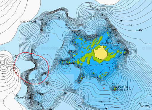
Dunaff Head
2019: We had deep boat with DL+ on the Laurentic with shallow boat, SD+, on Dunaff Head. Both ended up jealous of the other. Dunaff Head was a stunning dive site. We dropped in just to the north east of the small island at the mouth of Lough Swilly over a rock at ~4 m. There is some gullies and it drops from 5m to +20m with lots of life around. Best part were the huge shoals of schooling fish found by divers. Some missed the schools of fish below them on their safety stop. Shame but lots of life around the head and again a non-tidal site.
Corientes – 33m
Know locally as “Mickey Willies Wreck” this converted trawler was patrolling off Malin Head when she hit a mine. The boiler is the highest part of the wreck. The collapsed steel plates provide shelter for an endless number of lobsters.
Tor Rocks, Inistrahull – 27m
These rocks lie to the north of Inistrahull. The north face drops steeply from 10m to 27m to meet a series of gullys on the bottom that run out in a north westerly direction. They provide a safe haven from strong tidal currents for marine inhabitants. Shoals of Pollack and Bib are common sights.
Iris/gully Inistrahull – 15m
Stranded and lost on the eastern end of Inishtrahull in wind condition ENE force 6. Much of the wreckage lies in a narrow gully that cuts through the island. It starts at 15m and rises to 5m in places, but mostly stays about 12m. Most of the gully is only wide enough to permit one diver through at a time unless you are stacked on top of each other. It extends for approx. 100m with vertical walls carpeted in jewel anemones and, strangely enough, studded with shiny brass portholes! It’s hard to know if the portholes are kept glistening because of abrasive wave action or divers mits trying to remove them! There are a number of boulder chokes along the way which you can crawl under (leave your twinset behind!) or fin over. Any atlantic swell (which is most of the time) makes this a challenging and interesting dive. Upon returning to the entrance of the gully, there is a large patch of white sand and if you are lucky, the may be large schools of pollack swarming in the area. This dive makes for a wonderful second dive after one of the deeper wrecks.
2019: We had a look at Tor Rocks but due to the tide and swell decided to take shelter at Inishtrahull instead and dive the Iris – but we managed to get the wrong end of the gully. Nice gully, very sheltered and safe but not what was described in the dive guide with lots of portholes. Where we dived (B) vs. where we should have dived (A) below. So we got the wrong end of the gully for the wreck but the gully itself was lovely and again a non-tidal site. Relatively close to Tor Rocks so was a good back up.
Carthiginian – 58m
This 4,500 tonne steamship detonated a contact mine laid by a german submarine five north of Malin Head. She was carrying general cargo and now lies NW-SE in 58m on a coarse sand and shell bottom. She is somewhat flattened but still retains the shape of a ship. Her bow remains in tact and is the highlight of the dive.
Castle Eden – 33m
This scenic old steamship (1170 tonnes) lies in 33m on a clean bottom of mussel shells and coarse gravel. She was carrying a cargo of coal and timber when torpedoed by a german submarine. The huge boilers stand 5-6m proud of the seabed. Due to little sport diving in the area the wreck still contains wartime ammunition spread around her stern gun mounting. The wreck is literally crawling with lobsters and conger eels. The clear green light and shoals of coalfish make for a very atmospheric dive: Sarah’s personal favourite!
William Manell – 30m
A fishing trawler built in 1917 and used as mine sweeper during WWII. Her fate is somewhat of a mystery. One story says that she was abandoned by her crew after the cook, who was steering, had bounced her off a rock. The wreck lies in about 30m on her port side and although broken in the middle, she is relatively intact. Beware of fishing lines and nets. An extract from Mark Lee’s log book a very long time ago…
The wreck lay in sand – sandy beach kind of sand! There were lots of large congers hiding in the wreck and plenty of ling sneaking about in the darkness under the bow. There were fish everywhere, too many to remember!
Devils Cut – 18m

The Devil’s Cut
This is probably one of the most dramatic shore sites in the country, but with a westerly swell can be hazardous. It is a calm site only. Excerpt from Sarah Bothwell’s log book, 2003:
The gully rises and falls from 18m up to 4m and was so narrow in places that you could touch both walls, which were as smooth as butter. The scenery was stark with only a lone lobster to be seen. Lots of big boulders block the way. As I peered under one boulder, contemplating if I could fit thru, I was sucked through by the swell! At this point we arrived into a big cavern that led out to sea. It was a bit surgy but probably possible to swim out to sea if you stay deep. The scenery and rock formations were spectacular…like no other site I’ve dived. Make sure your cylinder is full if you are aiming to go straight thru and out the east side
2019: A final non-tidal site. This site is not dependent on the tides as long as you stick close to the wall; however it is completely dependent on the sea state. Any sort of large waves will deem this site not diveable. The diagram above is great. We dropped divers on the seaward side of Devils Hole to find a cave through which they could enter the gully. We were dropping divers over the entrance to cave 1 so most missed it. But most found the second cave entrance. The gully itself was very nice, smooth with some life but not a lot.
Cumberland – 58m
This steamer (10,939 tonnes) lies NW-SE in 58m and was torpedoed while carrying steel and general cargo. It is really a dive for trimix divers. She still resembles the shape of a ship but her hull plating has fallen outwards and superstructure has collapsed. Her massive boilers stand upright. Rolls of lino, electrical insulators and nickel cutlery can be found. In addition there is lots of Royal Doulton china but you need to dig deep to see the good stuff!
U861 – 43m
This was one of the largest class of U-boats built by the Germans (type IXD2) and sunk as part of Operation Deadlight in 1945. She lies in a gully in 40 metres and thus difficult to locate on the sounder. An excerpt from Ian Marnane’s dive log:
An early start on Sunday (10:00 am!) and a lazy breakfast left us plenty of time to get excited about diving the U-861 again. The first time had been brilliant, but this time we would be better prepared for what we would see, so less wide eyed staring and more exploring the wreck. As we went down the shot line (as fast as possible!) we could see the outline of the submarine very clearly, and could see that the shot would bring us down right beside the conning tower, it couldn’t be more perfect! The visibility on the seabed was easily 30 metres, significantly better than the 15 – 20 metres we had experienced on out first U-861 dive.
U861 props
We immediately headed for the stern of the boat (the boat is broken up into three sections) and swam through the aft section, which is fairly narrow but can still accommodate a diver with twin twelve litre tanks (but don’t take my word for it). You arrive out of the aft section to see the twin propellers and propellers shafts. We then swam over the aft section and headed back to the conning tower, on the middle section of the U-861. This section is lying on its side, so the tower is on the seabed. The hatch is open, but too narrow for a diver, however it is possible to see right down into the submarine, and it is easy to imagine the crew scrambling up and down the ladder to the conning tower. Geoff also mentioned that the conning tower can be accessed from the other side of the boat, however we left that for the next dive. We then swam on to the forward section and managed to penetrate this section through a fairly narrow hatch (I did get stuck momentarily I must admit). The small amount of space within these boats in unbelievable, claustrophobics should definitely avoid joining the Irish Navy submarine fleet (it is all top secret, so don’t tell anybody else). Not a lot remains inside the boat (wooden decks have long rotted away, though there are still switches and other recognisable items attached to the walls), but the thought of being inside a WWII German U-boat is absolutely amazing. We swam through about 10 metres of this section, exiting through a hatch in the side of the boat. A quick look at our dive computers confirmed that it was time to head back to the shot-line and leave the U-861 behind. Like the Laurentic, we decided that we wanted to dive the U-861 many more times. I have a feeling that trips to Malin will become a regular occurrence, personally I could dive the U-861 for a whole week and not get bored, but why don’t you go and see for yourselves?

The O’Doherty Rocks (Garvan Isles) – 20m
This is an underwater reef running for hundreds of metres to the east of the Garvan Isles. There is a large system of potholes in the reef, at an average depth of 20m. They were formed by wave action rotating large boulders on a softer base rock. They can be up to six metres in diameter and some have joined up to make canyons. You should plan to get into and stay within the system for the entire dive (to shelter from any tidal currents). The visibility is better than in open water and the sea life is excellent and varied.
Racoon – 17m
This three funnelled destroyer (920 tonnes) struck the Garvan Island during a snow storm in 1918 with the loss of 100 lives. She was only recently discovered by sports divers and lies on a bouldery bottom in 17m. The props and gun are clearly visible. Moving away from the wreck there is plenty of marine life to observe. Beware of very strong tidal currents.
2019: So we were told by our local guide when exactly slack was. We got out there on slack. Faffed with the shot etc. so that first divers went in about 15 mins after slack.They got down fine but were supermanning on the shot on the way back up. Wave 2 divers didn’t go in. Too much of a run at that point.
Laurentic
The Laurentic was built by Harland and Wolffe in 1909, at a length of 550 feet and a width of 57 feet. After a short career as a liner she was fitted as a troop ship in 1914. In 1915 another refit saw her take on the role of an armed merchant cruiser. She was sunk in January 1917 after she struck two mines. This wreck can experience currents, but we do not have slack window information. It lies about 11 miles offshore so it’s a reasonably long spin to get out there. Again we call upon Ian Marnane:
A 15,000 tonne White Star liner at a depth of 40 metres (35 metres to the top). The size of the wreck alone is impressive, though it is quite badly broken up, as it has been subject to a massive salvage expedition (using explosives) in search of a cargo of gold ingots which she was carrying when sunk (apparently there are still some left!). Everywhere we went there was an abundance of life, loads of congers, shoals of fish, crawfish, lobster, dogfish…too much to take in. Although the wreck is broken up, there are still many recognisable objects, including the boilers, two large guns, an armoury (where there is still some ammunition) and other items which can be spotted during a dive (including toilets!). The dive time passed all too quickly, there is far too much to see on a single dive.
There are a number of sites in Lough Swilly that are non-tidal and sheltered from all but strong northerly winds (however, boats must be launched from Fanad head, a 1.5 hour journey from Malin head):
- The Pandonian can be found just inside Swilley Mor. Apparently it’s very nice with lots of life
- SV Florence lies close to shore in 10m. Has a cargo of granite blocks
- HMS Saldahna – a 38 Gun Frigate that ran aground on Swilly Rocks.
2019: Laurentic had a shot attached to it but the shot was quite low in the water at LW. We nearly ran over it with the boat. Have to haul yourself down the shot but once on the wreck there was nearly no water movement. Huge wreck with large, nearly intact boilers to be seen. If you’re lucky you might find one of the 22 blocks of gold that is rumored to be still lost on the wreck. This is a supposedly a non-tidal site and seemed fine on the bottom for all divers on our trip. Slack was due at 14:00 and we had first pair in at 14:20. Decent run on the shot though. Some bagged off but could be difficult to follow everyone if there’s a few divers drifting.
Portmore Pier
We did a night dive on the back of portmore pier with the promise of loads of huge congers. Not. A. Single. Conger. Saw lots of little squat lobsters out eating their feed and was cool seeing all the torches in the water, both in the water and also from the shore.
Safety
You need the usual boat safety equipment: O2, 1st Aid Kit, flares, VHF, GPS. Also make note of the following:
- Malin Head Coastguard
- VHF Channels 23, 85, 16, DSC 70
- Emergency services
- 112 (or 999) on land
- Recompression chamber
- Craigavon
- Galway, 091 524222
- Weather
- Weather Dial 1550 123 855 (or 853 for Ulster)
- RTE Radio1 (88-89fm) at 0602, 1253, 1655, 2355
- VHF 0103, 0403, 0703, 1003, 1303, 1603, 1903, 2203
- Warnings on VHF (channel 16) 0033, 0633, 1233, 1833
Tides
As mentioned, severe tides sweep around the headland in both directions. Dive each site on slack but remember slack is not always predictable. A minimum of 3 surface detection aids are a MUST (e.g. delayed SMB, collapsible flag, whistle, back-up torch, personal EPIRB). A diver, separated from his RIB, drifted for 7hrs before being found and we’ve experiences of divers drifting huge distances. If you start to drift unexpectedly deploy your dSMB immediately and do not let it go until you are safely in the boat.
Diver Coxswain
Diver pick ups must be swift and efficient, or other divers who have surfaced will be swept away in no time. Surface conditions should be constantly monitored for change in tide and unexpected surface of divers. At Portronan pier there is a very shallow reef system on the port side as you leave the harbour. Extreme care is advised when using the pier.
Local Facilities
Geoff Millar can provide self catering accomodation and gas fills including provision of oxygen and helium upon request.
Accommodation
The hostel that we use in Malin Head is called the Sandrock Hostel. To find out about availability call Rodney on 074-9370289. The cost is approximately ten euro per person per night. Bed sheets are provided. There is a large fully equipped kitchen, and a shed out the back for storing wet gear and hanging dry suits. Boats and cars can be parked on the quiet pier in front of the Hostel.
Amenities
The nearest petrol station and bank machine is in Culdaff, twenty minutes drive from hostel. There is a small supermarket three minutes drive from hostel, open from 8am until 10pm.
It’s better to bring cash though. As the kitchen in the hostel has plenty of room and space to eat (and lovely views) we usually bring our own food with us too.
Entertainment
The cottages and the hostel are a bit remote from the nearest pubs so it is a longish walk along the road that you drove in by. Otherwise, if you have a teetotaller on the trip (unlikely in DUSAC) with a car and license, you can run a taxi service.
If winds are northerly forget diving and take the Inishowen scenic drive. This is one of Ireland’s best scenic drives with stunning panoramas of the Atlantic and passing through the magnificent Gap of Mamore. En-route, you have the opportunity to visit the Doagh Famine Village, see Ireland’s most northerly point “Malin Head” (from land!), Greencastle Maritime Museum and Planetarium, and the Donagh Cross in Carndonagh.
Info
You can get more information about the area from the following sources:
- Underwater Ireland book
- Dive Ireland
Getting there
There are two main ways to get to Malin Head from Dublin. The first and most direct is to go straight up the N2 (the Ashbourne Road) thorough Slane, Ardee, etc until you come to Northern Ireland. Then follow the signs for Omagh and Londonderry.
The other way you can go, is to go straight up the M1 motorway until you reach the N33 (Dunleer Bypass). Follow this across to Ardee and then follow the same route as above. The advantage of this route is that it allows you to miss the little towns on the N2 that always back up badly.
Once in Derry you have an hour’s journey time remaining. Take the A2 and follow signs through Buncrana, Moville, Culmore. From Culmore take the R238 and follow signs through Muff, Carndonagh and eventually Malin Head (R242). At “Cross Roads Hotel” turn left and continue straight until the road runs ends at the sea. Accommodation is on right hand side as you face the sea.


